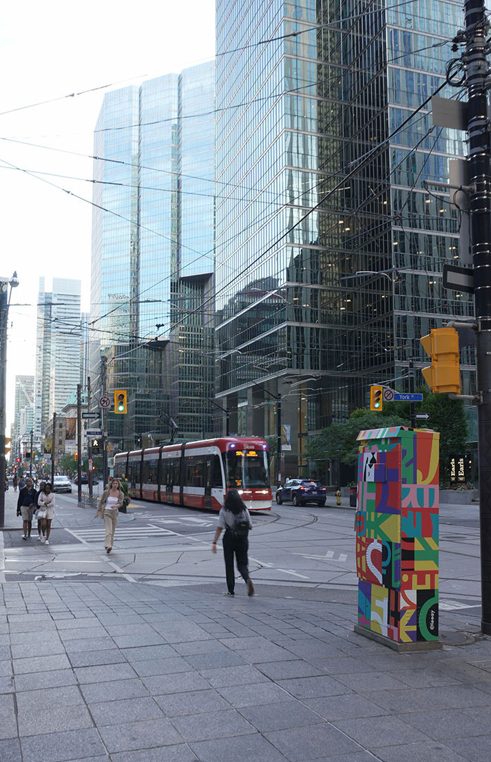

Toronto is a massive city. More than 6 million people live in the Greater Toronto Area, but I have to admit that getting around isn’t always easy to figure out when you first move here or come to visit. The city simply grew faster than its public transit network. But don’t worry, you’re in the right place! I’ve been living in Toronto since 2014, and I’m sharing all my local insider tips so you can navigate the city with complete peace of mind.
Before we dive in, don’t forget to follow me on Instagram, Pinterest, and YouTube.

Public Transit in Toronto
In Toronto, public transit is operated by the TTC (Toronto Transit Commission). The network was originally created in 1921 to replace the various private transit companies operating at the time. Back then, several independent operators ran bus and streetcar lines, but there was no unified service overseeing the whole system. In 1920, following a public vote, the city decided to consolidate everything under one roof: the Toronto Transportation Commission was born. It wasn’t until 1954 that it took on the name we know today.
Let’s walk through your best transit options to get around Toronto.
The Subway
Toronto’s very first subway line opened on March 30, 1954, at Davisville—where the TTC headquarters are still located today. It was not only the first subway line in Toronto, but in all of Canada. The line originally carried passengers between Union Station and Eglinton, both of which are still major hubs today.
Currently, we have 5 subway lines in operation:
- Line 1 – Yonge-University (yellow) – Toronto’s historic subway line runs north-south and loops at Union Station. It is the busiest line during peak hours. Pay close attention to whether you are heading northbound or southbound. It’s easy to get mixed up, so check the maps displayed in every station to orient yourself. Also, on the wall across from the platform, you’ll see the name of the next station printed clearly, a super handy trick to make sure you’re heading in the right direction!
- Line 2 – Bloor-Danforth (green) – This line takes you across Toronto from east to west. A couple of key differences from the other lines:
- The green line uses older subway cars compared to the yellow line. The cars are separate, meaning you cannot walk between cars while inside the train.
- The green line doesn’t have digital screens announcing the next station like the newer trains do. Keep an eye on the map, especially if you’re new and haven’t memorized the station order yet!
- Line 4 – Sheppard (purple) – Toronto’s shortest subway line features only 5 stops. To make a long story short: the original project proposed in 1985 planned for a much wider coverage. However, following government changes and budget cuts, the project was scaled back significantly to just 5 stations.
- Line 5 – Eglinton (orange) – Probably the most talked-about transit project in recent decades! Construction took about 15 years and heavily impacted local communities whose neighbourhoods were turned into massive construction sites. All the more reason to appreciate every trip on this train! It is Toronto’s newest LRT/subway line, having officially opened in February 2026. And for my fellow French speakers, station announcements onboard are made in both English and French!
- Line 6 – Finch West (light green) – In contrast, this line opened very quietly in December 2025. Perhaps because it’s located further from downtown, or simply because it was built within a reasonable timeframe compared to its orange counterpart. This line is also bilingual.
- Line 3 – Scarborough (blue) – You might be wondering what happened to Line 3 (Scarborough RT). It’s not an oversight! Line 3 was officially decommissioned in 2023 following a derailment. Pending the future extension of Line 2, shuttle buses are currently covering this route.
Subway Transfers
Unlike Paris, London, or New York, intersections between subway lines are rare in Toronto. In Paris, for example, there are multiple ways to reach a single destination, and you can easily jump between different lines. That is definitely not the case here. Which brings us to an important point to keep in mind: if one station experiences an issue and train service is halted, the entire section of that line grinds to a halt, often paralyzing the city. Remember what I said earlier, the network simply hasn’t grown at the same pace as the city!
Here is how to transfer between lines:
Line 1 to line 2: Transfers are available at Yonge-Bloor, St. George, and Spadina stations.
-
Pro-tip: Transfer at St. George! All you have to do is take the stairs to move between levels. At Spadina, on the other hand, you’ll end up walking through a hallway that feels like it lasts an eternity.
Line 1 to line 5: Transfers are available at Eglinton station and Cedarvale station (formerly Eglinton West).
Line 1 to line 6: Transfer at Finch West station.
Line 1 to line 4: Transfer at Sheppard-Yonge station.
Local Trivia: Lower Bay Ghost Station
To wrap up this historical section on the Toronto subway, here is a favourite piece of trivia I love sharing with visitors and newcomers. Tucked right beneath Bay Station lies a hidden “ghost station”: Lower Bay Station.
Back in 1966, the TTC experimented with an interlining system designed to let passengers travel between the Yellow and Green lines without ever having to switch trains. Lower Bay was built to facilitate this connection. In practice, however, the logistics were a total nightmare, and the system was completely abandoned after just six months.
What you might not realize is that you’ve probably already seen this subway station, even if you’ve never set foot in Toronto! Today, it serves as a filming location for movies and music videos. Our local icon Drake filmed parts of his What’s Next music video right here, and you can also spot it in blockbusters like Suicide Squad and The Matrix.
The TTC also uses Lower Bay to move train cars between lines, conduct operator training, and perform equipment testing. People often call it an “abandoned” station, but it’s actually quite active, it’s just not open to the public like regular stations.
However, you might get a rare chance to visit! Every spring, during Doors Open Toronto (an event where hidden or historic buildings open their doors to the public for free), Lower Bay occasionally opens up. The station doesn’t participate every single year, and when it does, the lineup is long, but it’s a fantastic experience and one of Toronto’s favourite hidden mysteries to explore.
Future Transit Projects: The Ontario Line
If you walk around Toronto right now, you’ll notice massive construction sites at major intersections like Queen & University, Front & Berkeley, or King & Bathurst. You’re looking at the future Ontario Line, a brand-new subway line currently under construction!
Once complete, it will connect Exhibition Place (home to BMO Field where Toronto FC plays, check out my complete guide to watching a game in Toronto!) all the way to Eglinton and Don Mills Road. It will cut right through downtown, intersecting with Line 1 (Yellow) at Osgoode and Queen stations, Line 2 (Green) at Pape station, and Line 5 (Orange) at Don Valley station. Fun fact: it will officially take over the Line 3 title, reusing the number left vacant after the Scarborough RT shut down in 2023.
Don’t hold your breath for the opening date just yet. While the city points to 2030, Metrolinx (the agency in charge of the project) has avoided committing to a firm launch date. But as Toronto residents, we can’t wait for construction to wrap up so we can move around these different parts of the city much more seamlessly!

The Streetcar
Toronto’s streetcars are iconic, with their bright red color standing out from blocks away. They are such an integral part of the local landscape that they help us instantly spot when a movie or TV show claiming to be set in New York was actually filmed right here in Toronto!
But let me step back for a moment to share the story of North America’s largest streetcar network. The system dates all the way back to 1861, when horse-drawn streetcars first took to the streets. Electric streetcars didn’t arrive until 1892. I find it mind-blowing that it’s that old, these tracks have witnessed so many stories, people, eras, and styles! If the passengers who rode those very first streetcars met the commuters riding them today, the culture clash would be immense. But I digress!
Today, Toronto’s streetcar network consists of 11 daytime routes and 7 night routes (part of the Blue Night Network). The vast majority of these lines run east-west across the city. Only a few run north-south, which is precisely why the future Ontario Line is so eagerly anticipated!
Back in the 1950s, cities around the world were tearing up their tracks to make room for cars. Toronto considered doing the same, but a group of dedicated citizens fought tirelessly to save them. It turned out to be a brilliant decision: today, Toronto’s streetcars move thousands of people across the city every single day. The core structure of the network hasn’t changed much since the 1970s, aside from a few tweaks and ongoing modernization.
The biggest evolution has been the fleet itself. Toronto’s nostalgic, classic streetcars were gradually retired to make way for modern, European-style low-floor vehicles. Purists might argue that the old streetcars had way more character, but from a practical standpoint, the new streetcars are vastly more accessible for wheelchair users, strollers, and anyone with mobility needs.
This transition took place between 2014 and 2019. I still remember the excitement of seeing those sleek new streetcars on the tracks for the first time, they felt like something straight out of the future! The rollout took much longer than planned because the manufacturer, Bombardier, faced major delivery delays.
The next major project on the horizon is the Waterfront East Streetcar line, intended to connect Union Station to Cherry Beach and serve the new Biidaasige Park (which offers incredible views of the CN Tower and the Toronto skyline). But as always in Toronto: don’t hold your breath just yet. There’s no firm launch date, it will be ready when it’s ready!

Tips for Riding the Streetcar in Toronto
- The 500-Series Route Numbers: Streetcar route numbers always start with a 5. If a local tells you to jump on the 511 or the 504, you instantly know they are referring to a streetcar and not a regular bus!
- Absolute Priority for Passengers: Because streetcars stop in the middle of the street, drivers traveling behind or beside the vehicle are legally required to stop behind the open doors to allow passengers to board and exit safely.
- Shared Lanes vs. Dedicated Right-of-Way: Some streetcar tracks run in their own dedicated lanes separated from traffic, while others share the road with cars. Why? It all comes down to available space, on wider avenues, the city had room to isolate the tracks, whereas tighter streets force streetcars to share space with drivers.
- Dress for the Weather: Unlike subway stations, almost all streetcar stops are outdoors on street corners or safety islands. Dress accordingly, especially during those freezing Toronto winter months!
- My Favourite Scenic Route: If you want a fantastic view of the city, hop on the 509 Exhibition streetcar between Union Station and Exhibition Place. It’s my absolute favourite ride: it runs right along the waterfront, offering breathtaking views of Lake Ontario, whether under the summer sun or framed by winter snow and icy waters.
Extra Insider Secrets: How to Ride Like a True Local
- The 501 Queen Record: The 501 Queen line is one of the longest streetcar routes in all of North America, stretching nearly 25 kilometers (15 miles) across the city.
- The King Street Transit Priority Corridor: Since 2018, streetcars get absolute priority on King Street between Bathurst Street and Jarvis Street. Passenger cars are not allowed to drive straight through intersections; they must turn right at the first opportunity. This keeps the lane clear and ensures transit riders don’t get stuck in downtown gridlock.
- Vintage Streetcar Sightings: Every now and then, you might spot an iconic vintage streetcar from the 1940s through 1990s rolling through downtown. They usually come out for special occasions like Canada Day. I’ve bumped into them several times over the years, and it always puts a smile on my face, it gives the city such a charming retro feel. Fun fact: you can even charter them for private events !
- A Hidden Gem for Transit Nerds: If you love trains, check out the Halton County Radial Railway, a heritage railway museum located in Milton (about an hour’s drive from Toronto). To be precise, it’s a museum dedicated to electric urban and interurban transit. You’ll find retired TTC vehicles, streetcars from other Canadian and US cities, and even a historic London tram from the UK.
- The San Francisco Connection: If you’ve ever visited San Francisco, you might have spotted a streetcar painted in Toronto colors. I saw it after my very first year living in Toronto and got super excited, taking it as a sign from my new home! As it turns out, that specific streetcar originally came from another US city and never actually ran in Canada. However, it is true that former TTC streetcars operated in San Francisco for a brief period between 1978 and 1979, long before they were retired (and way before I was born!).

Buses
I honestly didn’t expect to have so much to say about Toronto’s subway and streetcars, but I find it fascinating to dig into the history of a transit network we so easily take for granted today. Plus, I firmly believe that learning a bit about the history of a city, whether you’re just visiting or making it your new home, helps you understand it deeper and feel much more connected to it.
Toronto’s bus network is massive, featuring anywhere between 140 and 190 routes depending on seasonal schedules and express services. Simply put: buses cover every single corner of the city that subways and streetcars don’t reach.
Tips for Riding the Bus in Toronto
- Requesting a Stop: To request a stop, pull the yellow cord along the windows or press the stop button on the poles.
- Accessibility Features: Buses can “kneel” closer to the curb to lower the step height for passengers. Drivers can also deploy a ramp to easily accommodate wheelchair users.
- Priority Seating: The row of blue seats near the front is reserved for seniors and passengers with disabilities; these seats can also flip up to create space for wheelchairs and strollers
- Understanding Route Numbers:
- 1 to 189: Regular daytime bus routes.
- 300 to 399: Night routes (part of the Blue Night Network).
- 900 to 999: Express bus routes with fewer stops.
- Checking Next Bus Arrival Times: While you can easily track bus arrivals on Google Maps, here’s a handy insider tip: text the 5-digit stop number found on the bus stop pole to 898882 (898TTC) to instantly receive live arrival times via SMS.
- Request Stop Program (Night Safety): Between 9:00 PM and 5:00 AM, if you are traveling alone on a bus, you can ask the driver to drop you off between regular stops for your safety. Simply ask the driver at least one stop in advance, and they will accommodate your request provided it is safe to pull over.
Wheel-Trans
Wheel-Trans is the TTC’s specialized door-to-door transit service dedicated to passengers with disabilities or limited mobility. Riders can book trips in advance to be picked up by one of their accessible white minibuses. You can find all the details and registration requirements directly on the official TTC website.
Aside from these few local specifics, the bus system in Toronto operates very much like it does in most major cities around the world.

Operating Hours & Schedule
Subway:
- Monday to Saturday: 6:00 AM to 1:30 AM
- Sundays: 8:00 AM to 1:30 AM
- Statutory Holidays: Service starts around 8:00 AM.
- Overnight: When the subway shuts down, the Blue Night Network takes over with dedicated night buses.
Streetcars:
- Monday to Saturday: 6:00 AM to 1:30 AM
- Sundays: 8:00 AM to 1:30 AM
- Les jours fériés: le service commence vers 8h
- Overnight: Streetcars operate 24/7, but night routes switch their numbers from the 500-series to the 300-series (e.g., the 501 Queen becomes the 301 Queen Night).
Buses:
- Monday to Saturday: 6:00 AM to 1:30 AM
- Sundays: 8:00 AM to 1:30 AM
- Les jours fériés: le service commence vers 8h
- Overnight: Daytime bus routes also hand off service to 300-series night bus routes.
Night Network Frequency: Between 1:30 AM and 5:30 AM, night buses and streetcars run approximately every 30 minutes.
Fares & How to Pay
Surprisingly for a major tourist destination, Toronto does not offer multi-day transit passes for visitors. However, the system is flexible and easy to navigate once you know how paying works!
- Single Adult Fare: $3.30 CAD (2.12€ / 2.36USD)
- Fare Capping (Replacing Monthly Passes): The old physical monthly pass is a thing of the past! It has been replaced by automatic fare capping. Once you pay for 47 eligible trips in a single calendar month using the exact same payment method, all subsequent trips for the remainder of the month are completely free.
- Accepted Payment Methods: You can tap on and off using a physical credit or debit card, contactless mobile payments (Apple Pay, Google Wallet on your phone or smartwatch), or a physical Presto Card (more on that below).
Good to Know: The 2-Hour Unlimited Transfer
A single fare gives you 2 hours of unlimited travel across the entire TTC network.
Here is how it works: say you hop on a streetcar, then tap into another streetcar 25 minutes later, the card reader will display “Transfer Accepted” (or $0.00). You can then head down into the subway 15 minutes after that, and keep riding as much as you like within your 2-hour window. If you just need to run a quick errand across town, your entire round trip might only cost you a single fare!
Two essential rules to keep in mind:
-
Always tap at every transfer. Even though your transfer is included and free within the 2-hour window, you must tap your card or device every single time you enter a new vehicle or station turnstile.
-
Stick to the exact same card or device. Even if your credit card is linked to both your iPhone and your Apple Watch, the reader sees them as two separate payment methods! If you tap in with your phone and then tap your watch for the transfer, you will be charged twice. If you start your trip with your phone, keep using your phone for every transfer during those 2 hours.
Connecting Beyond Toronto: The One Fare Program
If you plan to head outside Toronto proper and connect with neighbouring transit networks, your TTC transfer is completely free within that same 2-hour window thanks to the Ontario One Fare Program.
We use this all the time when taking the GO Train to visit Dixie Outlet Mall (home to an incredible Nike Clearance Store, definitely a topic for another article!). You can take the train, hop right onto a local MiWay bus in Mississauga from the station, and head to the mall without paying a second fare.
The Presto card
The Presto Card allows you to travel across Toronto’s transit system, and well beyond. In fact, a single Presto card works across 11 different transit agencies throughout the Greater Toronto and Hamilton Area (GTHA), and even up in Ottawa!
Before Presto, we used physical monthly paper passes. They were convenient because anyone could use them (you could easily share one pass between two people!), but if you lost it, you were out the $145 CAD it cost. With Presto, that risk disappears: you can register your card online so that if you ever lose it, you can simply freeze the card and transfer your remaining balance to a new one.
Another fantastic perk of holding a Presto card is the Presto Perks program. You get exclusive discounts across the city, such as 15% off admission to the CN Tower or up to 20% off select Toronto sports tickets! I’ll write a dedicated post summarizing all the best Presto discounts soon, just like my guide on the amazing perks of having a Toronto Public Library card.
How the Presto Card Works:
- Purchasing: You can buy a physical Presto card for $4 CAD at fare vending machines inside any subway station, select Shoppers Drug Mart locations, or Customer Care outlets.
- Loading Funds: Reload your card at station machines, online via the Presto app, or at participating retailers.
- Digital Wallet Option: You can either keep the physical plastic card or load a digital Presto card directly into your Apple Wallet or Google Wallet on your phone.
- Tapping: Always tap your card on the green Presto reader every time you board a TTC vehicle or enter a station.
- Pro-Tip (Autoload): When you set up your account online, enable the Autoload feature. Whenever my balance drops below $10, my card automatically reloads with $20. That way, I never have to worry about running out of funds when rushing to catch a train.
UP Express: From the Airport to Downtown Toronto
Please take a moment to appreciate this service, because it hasn’t always been around! Since 2015, the UP Express (Union Pearson Express) train connects Toronto Pearson International Airport directly to Union Station in downtown Toronto in just 28 minutes, with departures every 15 minutes.
Back in the day, getting to or from the airport meant taking a long bus ride that was heavily dependent on Toronto’s unpredictable traffic. I had a few nerve-wracking moments rushing to catch flights back then, so every time I step onto the UP Express today, I genuinely appreciate how fast and reliable it is!
Essential UP Express Info:
- Intermediate Stops: Between Pearson Airport and Union Station, the train makes three intermediate stops: Weston Station, Mount Dennis Station, and Bloor Station (where you can transfer to Line 2 subway).
- Operating Hours: Trains run every 15 minutes from roughly 4:55 AM to 1:00 AM daily.
- Fares: Pricing depends on how far you travel. As a baseline, a one-way adult fare between Pearson Airport and Union Station costs $12.35 CAD (7.93€/ 8.84USD). If you pay with a Presto Card (or tap your credit/debit card on the reader), the fare drops to $9.25 CAD (5.94€/ 6.62USD), far cheaper than an Uber or taxi, and completely immune to highway traffic jams!
- Tap On AND Tap Off: Unlike the TTC where you only tap when entering, on the UP Express you must tap on at the platform reader before boarding AND tap off when you exit at your destination. If you forget to tap off, you will automatically be charged the maximum fare for the entire linee.
- Onboard Amenities: Free high-speed Wi-Fi is available onboard all UP Express trains.
- Prime Downtown Access: Taking the train from the airport drops you off right inside Union Station, Toronto’s primary transit hub, where you can seamlessly connect to Line 1 subway, streetcars, GO Transit, or VIA Rail to reach any part of the city.

Other Ways to Get Around Toronto
Taxis & Rideshares
Just like in any major global metropolis, taxis and rideshares (VTCs) are widely available across Toronto. Here ere are your main options, along with a few promo codes if you’re using these services for the first time!
- Uber: Get 40% off your first 2 rides (up to $10 off per ride). Code: v49grjccakb
- Lyft: Get 60% off your first 2 rides (up to $12 off per ride). Code: ASTRID36233
- Hoop: No promo code currently, but it’s one of the newer rideshare apps on the block. Originating in Europe, it is part of the Bolt group.
- Taxi: No promo codes here, but always ensure you choose a licensed Toronto taxicab. Look for the official City of Toronto municipal license plate or decal on the back bumper to make sure you are riding with a legally authorized vehicle.
Bike Share Toronto
Of course, you can always use your own bicycle to get around town, though do keep in mind that bicycle theft is a notorious issue in Toronto! Make sure to invest in a sturdy lock, and if you live in a condo building, take advantage of the designated secure bike storage rooms inside the parking garage.
As for public bike sharing, I am a massive fan! It’s convenient, affordable, and incredibly easy to use. Head over to my complete guide to using Bike Share Toronto for everything you need to know about rates, unlocking bikes, and station maps!
Getting around by Car
Another option for navigating Toronto is by car, whether you choose.
- Your own personal vehicle.
- A traditional rental car.
- A car-sharing service like Communauto.
- For all the ins and outs on navigating our roads and avoiding costly parking mistakes, read my complete guide to renting a car and driving in Toronto.
At this point in the guide, public transit in Toronto should hold no more secrets for you! Now that you know how to navigate the city like a true insider, make the most of your trip by checking out my list of 25 fun free things to do in Toronto.
If you are currently planning your upcoming trip, don’t miss my guide to spending money abroad without heavy bank fees and my guide to using e-SIM cards in Canada to stay connected seamlessly throughout your vacation!